
Five Days on the Rae Lakes Loop: Returning to Backpacking the Hard Way

There are easier ways to get back into backpacking after an eight-year break. The Rae Lakes Loop is not one of them.
Nestled in Kings Canyon National Park, in California’s Sierra Nevada Mountains, the roughly 41-mile route begins at the trailhead at Road’s End at 5000 ft and climbs to just under 12,000 ft at Glen Pass.
The route passes through river valleys, dense forests, granite-walled canyons, alpine meadows, and some of the most beautiful high-country lakes in the Sierra Nevadas, possibly the entire US.
Me and three fellow hikers traversed the loop clockwise taking five days, camping at Upper Paradise Valley, Arrowhead Lake, Charlotte Lake, and Charlotte Creek.
For the past couple of years, I’ve been mostly concentrating on riding dirt bikes and downhill mountain bikes. Neither of those sports is easy, and both are very demanding physically. But backpacking is much different and this was to be my first backpacking trip since 2018. My preparation was lacking at best. About a week before the hike, I threw on my (new) boots, loaded up my pack and walked two miles around my neighborhood near Atlanta, GA. ‘Pathetic’ doesn’t even begin to describe how unhelpful that was in preparing me for what I was about to face. Not a training plan I would recommend.
I do, however, have a lifetime of experience operating outdoors, carrying heavy loads, and managing myself when I’m both tired and uncomfortable and that background gave me the confidence - and probably the stubbornness - to think I should risk this trip without adequate conditioning. But, if I re-learned one thing from this particular hike, it’s that experience doesn’t replace preparation. The first two days made that point very clearly to me. It’s a lesson I insist on re-learning every few years.

Our Route
Our five-day clockwise itinerary:
Day 1: Road’s End to Upper Paradise Valley
Day 2: Upper Paradise Valley to Arrowhead Lake
Day 3: Arrowhead Lake through the Rae Lakes Basin and over Glen Pass to Charlotte Lake
Day 4: Charlotte Lake to Charlotte Creek
Day 5: Charlotte Creek to Road’s End
Going clockwise meant entering through the Woods Creek side of the loop and saving Glen Pass - the high point and crux of the route - for the third day. It also meant gaining elevation over the first two days as the terrain gradually transitioned from the lower canyon into the Sierra high country.
On paper, this trip looked manageable. Years earlier I’d done multiple trips to Jackson, WY to climb in the Tetons, sometimes with not a lot of preparation. Those trips, including a one-day summit of the Grand Teton, were hard but doable. But I was in better climbing and hiking shape on those trips. On the Rae Lakes loop, I knew that carrying five days-worth of food, clothing, and equipment, over 40 miles including to 12,000 ft at Glenn Pass, would be demanding.
My participation on this adventure came together unexpectedly. About three weeks earlier my wife’s uncle Bill, called to tell me about the trip. He had acquired a four-person permit for the Rae Lakes Loop. Three of the four spots were already committed, and he needed a fourth person – and he needed an answer quickly. I talked it over with my wife Suzanne who told me I should go for it. I’d wanted to do another big backpack trip in the mountains for years, but the opportunity just hadn’t presented itself. Well, here it was. When I agreed to go, I knew immediately that I didn’t have a lot of time to prep, either for gear or physically. On top of the short notice, Suzanne and I have a pretty demanding daily schedule running The Cipher Brief, a national security media company. Against a backdrop of unprecedented geo-political change, technological advancements, increasing tension and ongoing hostilities in Europe and the Middle East, our day-to-day requirements are robust to say the least.
It would also be my first time doing anything of this significance in the Sierra Nevadas, and of the other three who I would be joining, I only knew Bill. I would be meeting Mark and Steve one day before we were scheduled to leave the trailhead.
But in spite of these complicating factors, I felt comfortable joining this team. Bill is a retired emergency-room nurse from Lompoc, California. Mark and Steve are retired firefighters from the same area, both of whom had risen to the rank of fire chief. These guys were close friends and highly accomplished backpackers and hikers who did at least one big trip each year. It can sometimes be a risk, for all parties involved, to go on a big adventure with people you don’t know. But something told me this was going to be a good group, and I felt lucky to have received an invite.

Day 1: Road’s End to Upper Paradise Valley
Our hike began at Road’s End in Kings Canyon.
I was already in Los Angeles and my plan was to drive up and meet the team along the route. We were planning to stay at nearby Moraine Campground the night before the hike began. There was something surreal about waking up in the morning in Los Angeles, surrounded by relentless density and urban sprawl, and arriving just a few hours later at Kings Canyon National Park. The transition unfolded gradually at first, then dramatically, as Highway 180 pulls you deeper into Kings Canyon, twisting along steep canyon walls and above narrow gorges on a drive that itself was spectacular, exposed, and at times, genuinely harrowing.
Moraine Campground makes a convenient staging point for a trip beginning at Road’s End, just a short drive farther into Kings Canyon. Set at roughly 4,600 feet beneath tall evergreens and beside the South Fork of the Kings River, it offers the comfort of a developed campground while still feeling surprisingly remote. Its sites include picnic tables, fire rings and bear-proof food lockers, with drinking water and flush toilets available seasonally. Black bears are active throughout the area, so proper food and scented-item storage is essential. With sheer canyon walls rising nearby, limited cell service and the river running through the valley, Moraine is an ideal place to spend the night before entering the backcountry.
The next morning, we woke early, and after a quick breakfast we continued on Hwy 180 the short remaining distance. Then, true to its name, the pavement simply stops. Road’s End is remote, with just the essential facilities needed to launch a backcountry trip. It’s also a popular spot for day hikers. The permit station is where overnight hikers for the High Sierra and Bubbs Creek check in, collect their wilderness permits, and receive the latest information on trail conditions. The area also includes restrooms, trailhead parking for both day hikers and overnight backpackers, and large metal bear boxes. Visitors are advised to remove food, toiletries, and anything else with a scent from their vehicles before heading into the backcountry. Kings Canyon supports a healthy population of black bears, and the Rangers were careful to tell us that leaving food that smells tempting to a bear – even inside a parked car - can result in disappointment when you return several days later to shattered glass, twisted metal, and a very expensive end to a memorable trip.


After checking in with the Ranger, getting our permit and a quick stop by the scales to weigh our packs, we were off. The first section of trail follows the South Fork of the Kings River toward Mist Falls. The trail begins relatively gently, which creates a false sense of comfort (it doesn’t last long). But my first mile with the new pack and new boots, felt pretty good. I’m no stranger to heavy packs, but starting out with new gear is always uncertain. We were on our way to Mist Falls.
Mist Falls provides one of the first major landmarks of the route and is an early indication of the scale of the terrain. Above the falls, the trail climbs into Paradise Valley, leaving the river below as canyon walls rise sharply on both sides.

Our target for the day, and where we planned to camp for the first night, was Upper Paradise Valley.
Upper Paradise Valley is one of the best-known overnight stops on the clockwise Rae Lakes Loop, located roughly 10 miles from Road’s End. Rather than a single compact campground, it is a broad backcountry camping area tucked beneath the trees along the South Fork of the Kings River with numerous established tent sites spread beneath the trees near the river, offering enough room for multiple groups without everyone being directly on top of one another.
Permanent bear-resistant food lockers are located in the area, although hikers are still required to carry approved bear canisters and should never assume space will be available in the boxes.
When choosing a spot, the standard backcountry etiquette is to use an existing hardened site rather than creating a new one, give other groups as much privacy as the terrain allows, and ask before setting up close to an occupied camp.
Day 1 was a hard push that took a lot more than I thought it would and foretold the challenge that was still ahead of me. The sun was out, and we had a few hours of warm weather left, so after we finished setting up camp, a swim in the river felt great.

Day 1 Details
Starting pack weight: 44 lbs
Weather and temperature: Sunny, with no precipitation predicted for the duration of our hike. Temps were high 70’s/low 80’s during the day, and mid 40’s at night.
How my new boots performed: Great on day 1. I was confident they would end up being the right choice.
What I ate for dinner: Mountain House Chicken & Dumplings
Memorable Sightings: One bear, and one rattlesnake. The bear didn’t really care that we were there. The rattlesnake wasn’t happy about it.
Day 2: Upper Paradise Valley to Arrowhead Lake
Leaving Upper Paradise Valley the next morning, we continued along the route toward Woods Creek, and the next major landmark along the route – a footbridge across the creek.
The Woods Creek suspension bridge is one of the signature features of the Rae Lakes Loop. Crossing it with a heavy pack is more memorable than the photographs suggest. The narrow bridge moves noticeably beneath each step, bouncing and swaying as your weight shifts across the suspended walkway. A loaded pack raises your center of gravity and adds momentum to every movement, making a slow, steady gate a requirement. The cables and wire sides provide some protection, but the bridge remains open and exposed.
Looking down at the water and rocks below while the deck moves beneath your boots has a way of sharpening your focus. It is not an especially long crossing, but it demands concentration - and you are very aware that this is not a place to stumble.

Once across Woods Creek, the route turns south onto the John Muir Trail and the landscape changes as the route begins a long, steady climb toward Dollar Lake and the Rae Lakes Basin. The grade is rarely dramatic, but it is persistent - roughly four miles and 1,700 feet of elevation gain before reaching Dollar Lake.
As we gained elevation, the forests began to open and give way to more prominent granite terrain. Dollar Lake offered the first preview of the lake basin ahead, followed by Arrowhead Lake, where we stopped for our second night.
Arrowhead Lake sits beneath steep granite slopes in a setting that immediately feels more alpine. By then, we had climbed substantially from Road’s End, and both the elevation and the accumulated effort were apparent.
Day 2 was another hard one. Roughly 10.5 miles and approximately 3400 feet of elevation gain. By the time we reached Arrowhead Lake and our campsite at roughly 10,300 feet, I had developed a mild case of altitude nausea - a reminder that previous experience does not make anyone immune to elevation sickness. After dinner I turned in early to try and get some sleep. Fortunately, it faded during the night, and I felt ready and back to normal the next morning.
This was the day the trip began to feel like a true Sierra adventure. We were no longer approaching the high country. We were surrounded by it.

Day 3: Arrowhead Lake, Rae Lakes, Glen Pass, and Charlotte Lake
The third day was the centerpiece of the trip.
From Arrowhead Lake, the trail continues through the Rae Lakes Basin, passing a succession of clear alpine lakes surrounded by granite peaks. This is the landscape that gives the loop its reputation - and the section most likely to appear in photographs of the route.
Fin Dome rises prominently above the basin, providing one of the route’s most recognizable views. The Painted Lady, with its streaked and contrasting rock, dominates the approach toward Glen Pass.

It is an extraordinary, inspiring place, but the scenery does not diminish the reality of the climbing. Glen Pass waits at the southern end of the basin, and from below, the climb looks appropriately serious.
The trail rises through increasingly stark terrain, leaving the lakes and trees behind. Seemingly endless Switchbacks lead across broken granite and exposed slopes toward the narrow pass. With a multi-day pack, every step above 11,000 feet requires deliberate effort.

At 11,978 feet, reaching Glenn Pass with a multi-day pack is not a casual achievement.
Standing at the top, we could look back over the Rae Lakes Basin and ahead toward the Kearsarge and Charlotte Lake country. It was the high point of the route in every sense: the highest elevation, the hardest sustained climb, and one of the most rewarding views of the trip.
For me, it also marked a turning point. The first two days had tested whether my body would adapt quickly enough. Reaching Glen Pass confirmed that it had and I was starting to feel more comfortable in the high country again.

If you climb or hike in high country, then you know that descending requires its own type of concentration, and the descent from Glen Pass is no exception. The trail drops sharply from the exposed ridgeline through loose granite, talus and tight switchbacks. Some hikers argue that descending is harder on the body than climbing. Though our hard elevation gain was over, on the climb down from Glenn Pass we encountered numerous parties that were on their final push to Glenn Pass hiking the route counterclockwise.
As we lost elevation, the stark alpine terrain gradually softened: small high-country lakes appeared below the pass, vegetation returned, and the trail opened onto broader views toward the Charlotte Lake and Kearsarge Pass country.
After roughly two miles, we reached the trail junction and turned off the main route for the final descent through lodgepole and foxtail pine toward Charlotte Lake, sitting several hundred feet below. By the time we reached the shoreline and selected a campsite for our third night, the climb over Glen Pass was behind us - but the accumulated effort of the day was still very much present.
Charlotte Lake offered a quieter, more sheltered setting after the exposure of Glen Pass. We enjoyed a quick dip in the lake, while the sun was still out. With the hardest climb behind us, camp that evening carried a different, more relaxed mood. Day 3 was done. Total distance- approximately 7 miles, with 1700 feet of elevation gain.
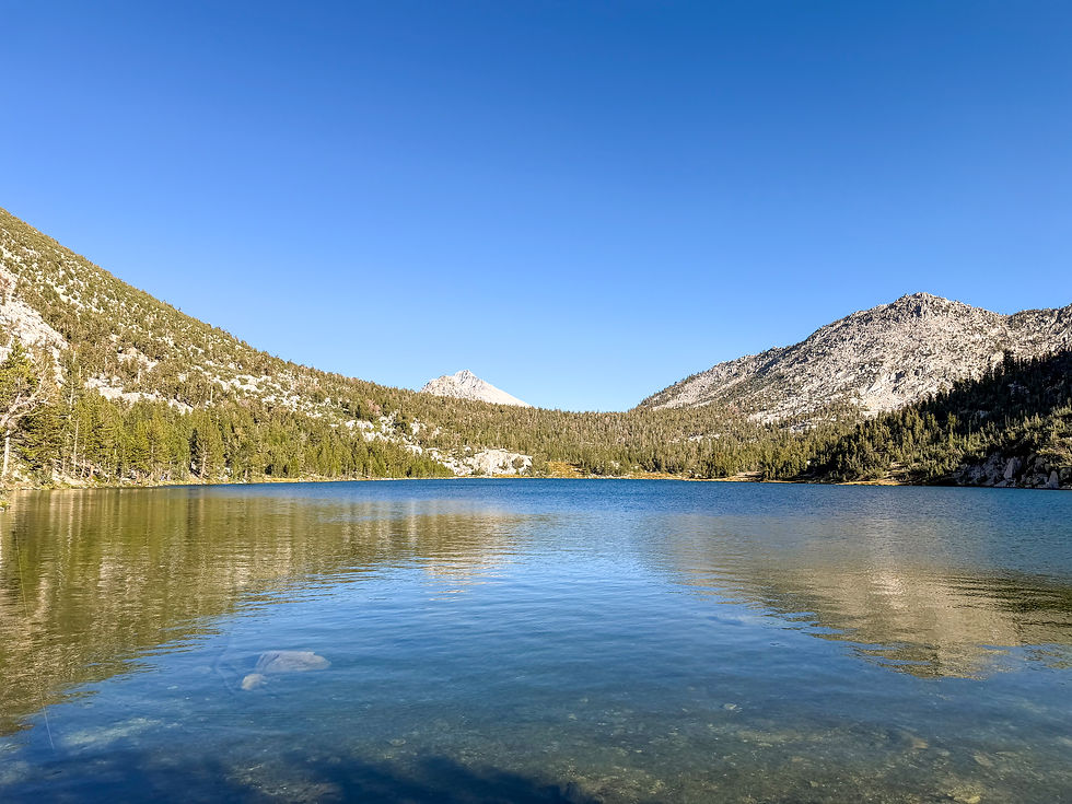
Day 4: Charlotte Lake to Charlotte Creek
The day began with the knowledge that most of the remaining route would trend downhill.
From Charlotte Lake, we returned toward the main trail and descended into the Bubbs Creek drainage.
The high alpine terrain gradually gave way to meadows, forest, and the granite walls of the canyon.

We camped near Charlotte Creek for our final night. Once again we got to camp with just enough sunlight and warmth left in the afternoon to warrant a quick dip in the creek. So far, I’d be able to get a swim in at least once each day.

There is something distinctive about the last camp of a trip. Most of the food is gone. The bear canister is lighter. Packing and unpacking have become automatic. Everyone knows that civilization is within reach, which sparks an “almost there” vibe.
It was an opportunity to take stock of the trip: four days completed, Glen Pass behind us, and one final descent back to Road’s End. Total distance for day 4- approximately 8 miles.
Day 4 highlights
How did I feel? Starting to feel one with nature again
Any foot, knee, or shoulder issues? None
What was the mood of the group? Incredibly relaxed and collaborative, the entire time.
Wildlife sightings (Two bears tried to enter the camp, and we tried out the Park Service’s recommendation to “Haze” the bears by chasing them.
Thoughts during the final evening
Chasing Bears is way more fun than it sounds
Day 5: Charlotte Creek to Road’s End
As I awoke on the final morning of the trip, I felt that my reintroduction back into the wilderness was complete. In just 5 short days, I had come to once again relish the feeling of sleeping on the ground. The sounds of the wilderness had become familiar. The routine of camp had started to feel routine – wake up, boil water, brew coffee, break camp, pack up, move out. The discipline of fieldcraft was an old friend that I hadn’t spoken with in far top long.
Our route on day 5 followed Bubbs Creek back toward Kings Canyon, shedding more than 2,000 feet of elevation along the way. From Charlotte Creek, the trail continued its long descent through the increasingly enclosed walls of the lower canyon, at times dropping steeply across switchbacks before passing Sphinx Creek Junction - the final legal camping area before Road’s End.
As we descended, the forest grew denser, the vegetation thicker and the temperature noticeably warmer. The thin, cool air of Glen Pass had been replaced by heat, insects, day hikers and the earthy smell of the lower-elevation woods. After crossing several channels of Bubbs Creek and the main bridge near the canyon floor, the trail rejoined the route we had followed five days earlier.
The final mile was enjoyable. How could it not be? We’d conquered the loop. I was relieved that everything worked out for me – gear, boots, body. I savored the final steps, knowing they would likely be my last for a while moving with a pack in the backcountry. I felt the cumulative effect of 5 days on my body, but finishing the route strong, and wanting more was an unexpected surprise.
Eventually, we walked back into Road’s End - the same place we had started, but with a much deeper appreciation for everything that lay beyond the pavement. Day 5 distance- 7.5 miles.

What the Rae Lakes Loop Demands
The Rae Lakes Loop is frequently described as one of the great backpacking routes in the Sierra Nevada. That description is deserved, but it can also obscure the difficulty. All Trails says that 63% of reviewers on their site rate this trail as “hard”.
I agree with that rating. But the terrain is inspiring, and the elevation gain, while relentless until you cross the pass, rewards you with simply stunning views that only get better the higher up you get.
This is a serious mountain route. It involves approximately 41 miles of travel, significant elevation gain and loss, remote terrain, changing weather, and a climb to nearly 12,000 feet.
Final Thoughts
Completing the Rae Lakes Loop after eight years away from backpacking was immensely satisfying. I benefited from the company of three very strong and experienced backcountry hikers.
Mark and Steve did a great job of leading the route, pace and the breaks for the full 5 days. Bill did an excellent job of planning the entire trip, getting the permit and making sure we didn’t forget to stop and take in the scenes.
I was pleased that my equipment worked, my food planning was sound, and my accumulated outdoor experience remained relevant. My choice of boots was perfect for me, and I didn’t get a single blister.
I would have benefited from considerably more conditioning. One two-mile walk with a loaded pack was not enough preparation, and I felt that most acutely during the first two days. My prior experience allowed me to manage the discomfort, maintain perspective, and continue moving efficiently, but it did not make those days easy. Had I undertaken this trip solo, then my transition to hiking at altitude may have been more subtle, but since I joined a group with three strong and pretty fast hikers, I felt my lack of conditioning from the first mile.
There is a useful distinction between knowing that you can do something and pretending it will not hurt.
I knew I could complete the loop, but I was also reminded that confidence is not conditioning.
More than anything, I was simply pleased that I could still shoulder a full pack, climb into the high country, cross a 12,000-foot pass, and finish the route feeling strong and ready to do it again.
Over five days, the Rae Lakes Loop delivered nearly every element of a classic Sierra journey: beautiful rivers with plenty of swimming opportunities, waterfalls, deep valleys, alpine lakes, bears, exposed mountain passes, granite peaks, and long miles under a loaded pack.
It was not the easiest way to return to backpacking.
It may have been the best one.


Comments